
Open Street Maps (OSM) underpins various layers and basemaps from Esri and the Eagle vector basemaps. Compass uses Open Street Map (OSM) to get posted speed limit data. However, because OSM is a community-driven system, it can sometimes result in inaccurate speed labels (e.g., OSM Speed limits that don't match the posted speed for that road). Here's a step-by-step guide on updating OSM, enabling Compass users to improve and enrich map data where errors occur.
Updating OSM requires you to sign up for an OSM account before making any changes. We can't make these changes directly through the Compass Road Intelligence platform. Note that to sign up for an OSM account, you'll need to temporarily disable any VPNs.
Step 1: Launch The OSM Editor
To update the OpenStreetMap (OSM) dataset, you have two options. We recommend using the OSM Editor as it's intuitive for most users:
- You can add one of the OSM layers from Esri to the map, find and click on the feature of interest and click on "Edit this Feature in OpenStreetMap"
- You can use the OSM editor (we recommend this option for most users)
No time to edit or Sign up? Add a note instead
If you just want something small fixed and don't have the time to sign up and learn how to edit OSM, it's easy to add a note.
Just go to the map and click the note icon. This will add a marker to the map, which you can move by dragging. Add your message, then click save, and other mappers will investigate. The downside of this approach is there is no guarantee your change will be accepted or how long it may take to be implemented by another user.
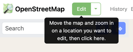
Step 2: Choose a Feature to Add or Modify
To edit a feature, navigate to the location you want and then press the Edit button at the top left-hand side of the screen:
The editor provides various features to add or modify:
- points are used to pinpoint specific locations, such as addresses, shops, and restaurants.
- lines help represent features like roads and waterways.
- areas are used to delineate boundaries, covering features such as buildings and residential zones.
You can zoom in to select parts of an asset using the line tool (e.g., to select a specific section where a speed limit applies) or zoom out and select the entire road.
Edit fields about the road such as Name, whether it's a one-way or multi-way street, the speed limit, the number of lanes, the surface type, and whether there are any structures.

Step 3: Update Feature Editor and Save
Once you've finished adding the details, simply close the feature editor by clicking the 'X' button or pressing the 'Esc' key. Don't forget to save your changes afterwards.
Step 4: Add Comments and Upload
Prior to uploading your changes, it's important to include a changeset comment that reflects the nature of your edits.
Please note it may take some time for any OSM updates to be reflected on both OSM and on Compass Road Intelligence.